2026-06-24 22:05:11 (UTC), 130km west of Caracas, Venezuela
10.435°N 68.472°W
Depth 10.0 km
Magnitude 7.5
The human catastrophe rolling out in Venezuela counts more than 1700 deaths and still more than 60,000 people missing. This followed the ongoing earthquake sequence that initiated with a M7.1 (later upgraded to M7.2) right-lateral mainshock near the triple junction of the South-American, Caribbean and Nazca Plates. At the epicentre, the Caribbean plate moves eastward relative to South America at a rate of about 20 mm/yr. This movement is primarily accommodated by a major system of right-lateral strike-slip faults, the San Sebastian Fault system traversing northern Venezuela. After nearly 40 seconds from slip onset, the slip continued turning this into a bigger magnitude M7.5 earthquake. Venezuelans reported a single continuous shaking, not a stop-start shaking. Obviously this is a complex earthquake source that ruptured fault segments as far east as Caracas, the national capital. The aftershock sequence continues into July, worrying that the largest aftershock to date had a magnitude of just M4.6 whereas we might expect one up to M6.5 following a M7.5 mainshock.
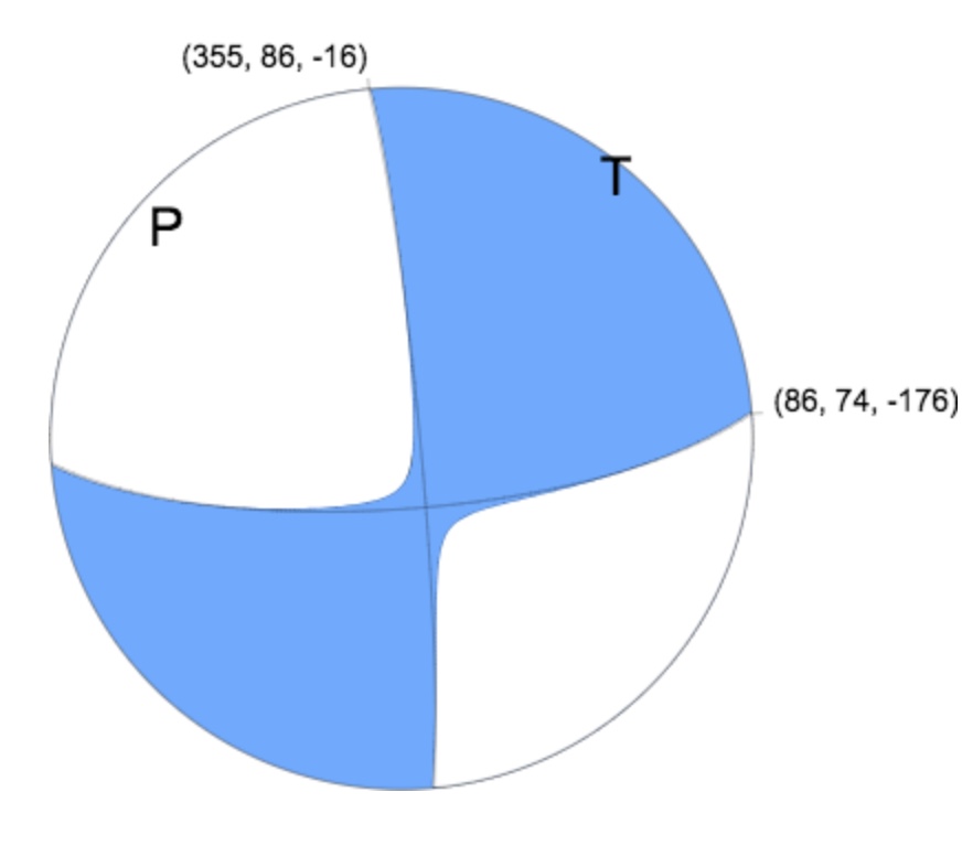
Figure 1 Focal mechanism from the USGS, pure strike-slip on the east-west plane.
In Caracas and other Venezuelan cities the shaking resulted in gross failure of buildings exacerbated by the underlying soil of variable depth which amplified shaking at periods comparable to those of tall buildings. This had happened before! In July 1967 Caracas was struck by a magnitude M6.6 earthquake with catastrophic results for tall buildings. This led the international earthquake engineering community to recognise that ground amplification could be attributed to a building’s foundations depending on their shear modulus, thickness and water content. This earthquake led to Venezuela’s first earthquake code which, if followed, should have at least prevented the characteristic building pancake failures during this sequence. So, were the codes followed or not, and if so did they not specify the shaking expected from a magnitude 7.5 earthquake on the nearby plate boundary (90 seconds of displacement – Figure 3). That begs the question of whether there were any strong motion instruments in Caracas and more widely in Venezuela. How much do we know of the amplitude and frequency content of the shaking?
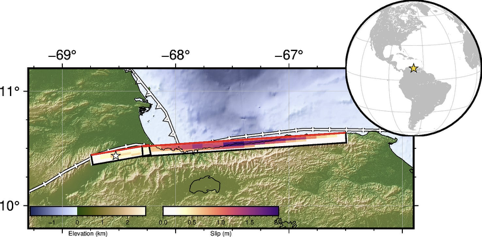
Figure 2 Map of the earthquake area showing the modelled faults and slip. Source: USGS. The star near the western end of the fault set is the M7.5 epicentre, and Caracas is at the eastern end of the faults. https://earthquake.usgs.gov/earthquakes/eventpage/us6000t7zp/finite-fault.
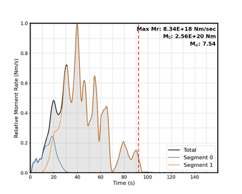
Figure 3 Source-time function for the June 2026 Venezuela earthquakes, by the USGS. https://earthquake.usgs.gov/earthquakes/eventpage/us6000t7zp/finite-fault
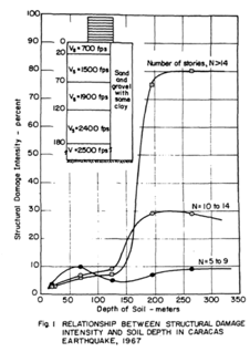
Figure 4 (from Seed and Alonso, 1974) Relation between structural damage intensity and soil depth.
Are there lessons for Australia? Does our earthquake loading code represent Australian earthquakes? Can the force-reduction factors in the code be justified on other than financial arguments? It is worth considering what the impact of a magnitude M7 earthquake near a major Australian city would be, bearing in mind that such an earthquake has never before occurred under Caracas since its founding in 1567. Will the basins underlying Perth and Sydney respond like that under Caracas? Can we ever prepare for something like that?
Reference
Seed, H. B. and Alonso, G. (1974), “Effects of Soil Structure Interaction in the Caracas Earthquake of 1967”, Proceedings, First Venezuelan Conference on Seismology and Earthquake Engineering, October.