
2026-06-24 22:05:11 (UTC), 130km west of Caracas, Venezuela
10.435°N 68.472°W
Depth 10.0 km
Magnitude 7.5
The human catastrophe rolling out in Venezuela is approaching 5000 according to figures released on 16 July 2026.
A recent tally puts the number of injured in the June 24 quakes at 16,740, and the number of homeless at 17,907.
Interim President Delcy Rodriguez renewed calls for international sanctions on Venezuela to be lifted to assist the earthquake recovery, saying the country had enough overseas assets to help finance reconstruction if blocked accounts were released.
This followed the ongoing earthquake sequence that initiated with a M7.2 right-lateral mainshock near the triple junction of the South-American, Caribbean and Nazca Plates. At the epicentre, the Caribbean plate moves eastward relative to South America at a rate of about 20 mm/yr. This movement is primarily accommodated by a major system of right-lateral strike-slip faults, the San Sebastian Fault system traversing northern Venezuela. After nearly 40 seconds from slip onset, the slip continued turning this into a bigger magnitude M7.5 earthquake. Venezuelans reported a single continuous shaking, not a stop-start shaking. Obviously this is a complex earthquake source that ruptured fault segments as far east as Caracas, the national capital. The aftershock sequence continues into July, worrying that the largest aftershock to date had a magnitude of just M4.6 whereas we might expect one up to M6.5 following a M7.5 mainshock.
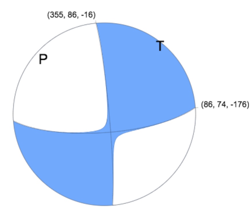
Figure 1 Focal mechanism from the USGS, pure strike-slip on the east-west plane.
In Caracas and other Venezuelan cities the shaking resulted in gross failure of buildings exacerbated by the underlying soil of variable depth which amplified shaking at periods comparable to those of tall buildings. This had happened before! In July 1967 Caracas was struck by a magnitude M6.6 earthquake with catastrophic results for tall buildings. This led the international earthquake engineering community to recognise that ground amplification could be attributed to a building’s foundations depending on their shear modulus, thickness and water content. This earthquake led to Venezuela’s first earthquake code which, if followed, should have at least prevented the characteristic building pancake failures during this sequence. So, were the codes followed or not, and if so did they not specify the shaking expected from a magnitude 7.5 earthquake on the nearby plate boundary (90 seconds of displacement – Figure 3). That begs the question of whether there were any strong motion instruments in Caracas and more widely in Venezuela. How much do we know of the amplitude and frequency content of the shaking?
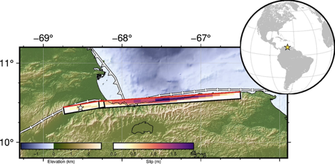
Figure 2 Map of the earthquake area showing the modelled faults and slip. Source: USGS. The star near the western end of the fault set is the M7.5 epicentre, and Caracas is at the eastern end of the faults. https://earthquake.usgs.gov/earthquakes/eventpage/us6000t7zp/finite-fault.
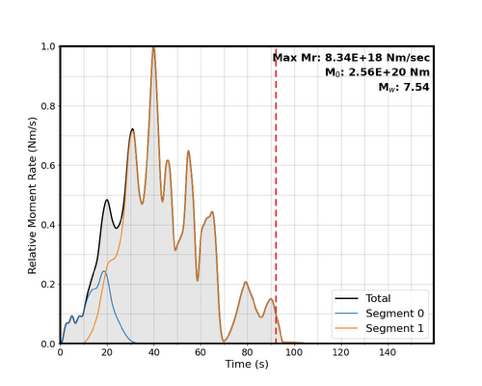
Figure 3 Source-time function for the June 2026 Venezuela earthquakes, by the USGS. https://earthquake.usgs.gov/earthquakes/eventpage/us6000t7zp/finite-fault
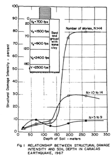
Figure 4 (from Seed and Alonso, 1974) Relation between structural damage intensity and soil depth.
Appendix Research in seismology and earthquake engineering in Venezuela
There have been many studies of earthquake risk in Venezuela and I have selected just a few of them. All concluded that the risk was high, that strengthening of buildings was a priority to stave off disaster in the next large earthquake.
January 1, 1983
L. Urbina, J. Grases
Venezuela has been affected by destructive earthquakes for the past four centuries. According to entries in the national seismic catalog, there have been about 180 earthquakes which have caused some type of damage to the country. The most catastrophic earthquake occurred on March 26, 1812, on the Bocono fault system and caused widespread destruction in the cities of Merida and Caracas and claimed an estimated 30,000 lives.
After the July 29, 1967 damaging earthquake (with a moderate magnitude of 6.3) caused widespread damage to the northern coastal area of Venezuela and to the Caracas Valley, the Venezuelan Government decided to establish a Presidential Earthquake Commission. This commission undertook the task of coordinating the efforts to study the after-effects of the earthquake. The July 1967 earthquake claimed numerous lives and caused extensive damage to the capital of Venezuela. In 1968, the U.S Geological Survey conducted a seismological field study in the northern coastal area and in the Caracas Valley of Venezuela. the objective was to study the area that sustained severe, moderate, and no damage to structures. A reported entitled Ground Amplification Studies in Earthquake Damage Areas: The Caracas Earthquake of 1967 documented, for the first time, short-period seismic wave ground-motion amplifications in the Caracas Valley. There was severe damage in the Los Palos Grantes suburb correlated with the depth of alluvium causing ground amplification in the area. The Venezuelan Government initiated many programs to study in detail the damage sustained and to investigate the ongoing construction practices. These actions motivated professionals in the academic, private, and Government sectors to develops further capabilities and self-sufficiency in the fields of engineering and seismology. Allocation of funds was made to assist in training professionals and technicians and in developing new seismological stations and new programs at the national level in earthquake engineering and seismology. Ongoing programs in Venezuela are being performed by FUNVISIS and by other national organizations.
Study on Disaster Prevention Basic Plan for the Metropolitan District of Caracas 2005
List of earthquakes in Venezuela (from Wikipedia)
Japan International Cooperation Agency (JICA)
Metropolitan District Of Caracas Bolivarian Republic Of Venezuela
Study On Disaster Prevention Basic Plan In The Metropolitan District Of Caracas In The Bolivarian Republic Of Venezuela
Final Report Summary
March 2005
Pacific Consultants International in association with Oyo International Corporation
Executive Summary
Study On Disaster Prevention Basic Plan For The Metropolitan District Of Caracas
Existing Problems and Target of the Master Plan
Caracas is the largest city of Venezuela and has a population of 3.1 million and 777 km2 of area. It also has the largest concentration of asset in the nation. Much more, it has a function of capital city with the administration of national government, national congress and the supreme court as well as the headquarter of national bank.
Caracas has experienced several large scale earthquakes since its history began in 16th century. The largest earthquake hit the city in 1812, when around 2,000 people lost their lives. The most recent earthquake in 1967, when about 1,800 buildings were damaged and 274 people died. Thus, Caracas has the possibility of large earthquakes such as 1812 earthquake or 1967 earthquake.
Caracas also has a history of frequent sediment disasters. In December 1999, Caracas was hit by a heavy rainfall caused by cold weather front from Caribbean Sea and debris flow was generated in the mountain streams of Catuche and Anauco. It caused death of around 100 people. Similar debris flow occurred in February of 1951.Thus, Caracas has possibility of debris flow such as 1951 or 1999 in future.
The disaster prevention administration in the Metropolitan District of Caracas is defined in the “Law of Organization for Civil Protection and Disaster Administration” issued in 2001. The responsibility of Civil Protection of national and regional level is clearly defined there and one of the responsibilities of the Civil Protection of ADMC is to prepare a regional disaster prevention plan for the Metropolitan District of Caracas but the plan is not being prepared. The national disaster prevention plan, which would be the guideline for the regional disaster prevention plan is not being prepared either.
Thus, the Metropolitan District of Caracas, the most important city of the nation, is under a threat of natural hazard such as earthquakes and sediment disasters. However, the disaster prevention administration is under development and the regional plan for disaster prevention is not being prepared yet.
Based on the above mentioned background, the target of the disaster prevention master plan for the area is as follows;
1. Even with the occurrence of 1967 scale earthquake or 1812 scale earthquake, the human lives will be saved. The assets damage will be minimized. The important function of the city such as main road, lifelines and disaster prevention administration function will be preserved.
2. Even with the occurrence of debris flow with the scale of 1999 Caracas by the rainfall of once in hundred years, buildings and human lives along the mountain streams will be saved.
3. Human lives will be saved from landslides or steep slope failures in the area.
Master Plan
1. Master Plan Projects
In order to attain the above targets, 20 projects were proposed and seven major projects were selected among them taking into account “significance”, “urgency”, “intention of the counterpart”, etc. The seven major projects are as follows;
Projects for “Making a Safer Caracas”
1. Seismic Reinforcement of Buildings (Ministry of Housing, FUNVI, Municipalities)
2. Seismic Reinforcement of Bridges (Ministry of Infrastructure)
3. Debris Flow Control Structures (Ministry of Environment and Natural Resources)
4. Resettlement of People Living in River Channels (Ministry of Planning and Development, Urban Planning and Environment Secretary ADMC, Municipalities)
Projects for “Acting Effectively in Emergency”
5. Early Warning and Evacuation (Ministry of Environment and Natural Protection ADMC, Civil Protection Municipalities)
6. Emergency Command Center (Civil Protection ADMC)
Resources,
Civil
Project for “Strengthening Coordination between the Government and the Citizens”
7. Strengthening Community Activities (Civil Protection National, ADMC, Municipalities)
Project Cost
~2,800 Million US$ for 16 years of period (~2% of GDP and 10% of National Budget) …..
| Date | Location | Mag. | MMI | Deaths | Injuries | Note | Ref |
| 2026-06-24 | Yaracuy | 7.2/7.5 Mw | IX | 1,943+[2] | 10,571 | Doublet earthquake, extreme damage | [3][4] |
| 2025-09-24 | Zulia | 6.2/6.3 Mw | VIII | 1 | 110 | Severe damage | [5] |
| 2018-11-24 | Trujillo | 5.2 Mw | VI | 2 | Minor damage | [6] | |
| 2018-08-21 | Sucre | 7.3 Mw | VII | 5 | 122 | Moderate damage | [7] |
| 2010-01-15 | Carúpano | 5.6 Mw | VII | 11 | Minor damage | [8] | |
| 2009-11-27 | Lara | 5.4 Mw | VII | Minor damage | [9] | ||
| 2009-09-12 | Carabobo | 6.3 Mw | V | 18 | Minor damage | [10] | |
| 1997-07-09 | Sucre | 6.9 Mw | VIII | 81 | 683 | Severe damage | [11] |
| 1974-06-12 | Lara | 6.1 Mw | VIII | 5 | 1 | Some damage | [12][13] |
| 1967-07-30 | Caracas | 6.6 Mw | VIII | 300 | 1,536 | Severe damage | [14] |
| 1929-01-17 | Cumaná | 6.9 Ms | IX | 200 | Severe damage / tsunami | [15] | |
| 1900-10-29 | Miranda | 7.6 Ms | 101 | 50 | Severe damage / tsunami | [16] | |
| 1894-04-28 | Mérida | 7.0 Mw | VIII | 350 | [17] | ||
| 1875-05-18 | Cúcuta | 7.5 Mw | IX | 10,000 | Extreme damage | ||
| 1853-07-15 | Sucre | 7.5 | Tsunami 15 m (49 ft) | ||||
| 1812-03-26 | Caracas, Vargas | 7.7 Mw | X | 15,000–20,000 | Extreme damage | ||
| 1766-10-21 | Sucre | 6.5–7.5 Ms | IX–X | [18] | |||
| 1641-06-11 | Caracas | 6.5 | 200 | Severe damage | |||
Lessons for Australia? Does our earthquake loading code represent Australian earthquakes? Can the force-reduction factors in the code be justified on other than financial arguments? It is worth considering what the impact of a magnitude M7 earthquake near a major Australian city would be. Will the basins underlying Perth and Sydney respond like that under Caracas? Can we ever prepare for something like that?
When Charles Bubb , David Rossiter and I founded AEES in 1990 immediately after the destructive earthquake under Newcastle NSW in December 1989, Charles was the Australian Government’s Chief Structural Engineer. He was head of a large group of structural engineers in the then Department of Works later Housing and Construction and had a lot of influence over the design and construction of Australian Government Buildings. Charles was able to usher through Standards Australia the first earthquake code in Australia that included the first earthquake hazard map of Australia, loading factors, structural design factors and consideration of foundations . Earthquake design was incorporated into the design of all major Commonwealth Government structures, hospitals, bridges, communications towers on Northwest Cape WA and Black Mountain Canberra , Parliament House Canberra and others.
Today the governments, Commonwealth, State and Territory, have no engineers, design and inspection has been outsourced, but to who? Who checks the inspectors? There is no central body keeping tabs on construction practices aimed at preventing collapse or minimising damage.
Few buildings or important structures are instrumented to measure their response in an earthquake as a check on the loading code design. Of those that are, the data are not made public, notably instruments on major dams, Sydney’s small nuclear reactor at Lucas heights, the Animal Health Laboratory near Geelong and the new Adelaide Hospital – all publicly owned. Australians would be surprised to know that they are in fact no better off in Australia than the citizens of Venezuela.
Earthquake monitoring in Venezula (to be continued)
Nine seismographs are listed by the ISC installed between 2003 and 2015, one of them a borehole installation for the CTBTO. Since then a major network of broadband seismographs was rolled out across Venezuela starting in the year 2020.
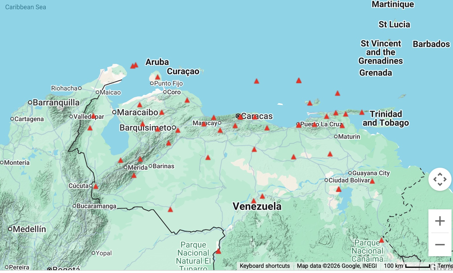
Figure 5 National network of seismographs prior to the 2026 earthquake sequence
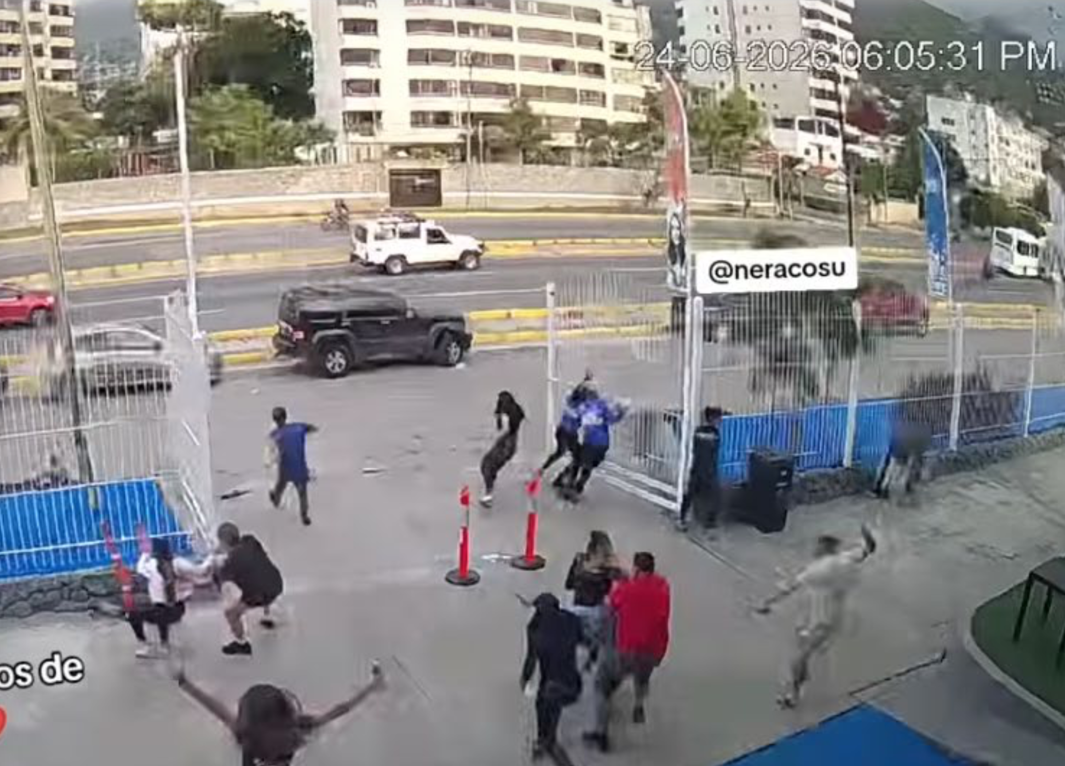
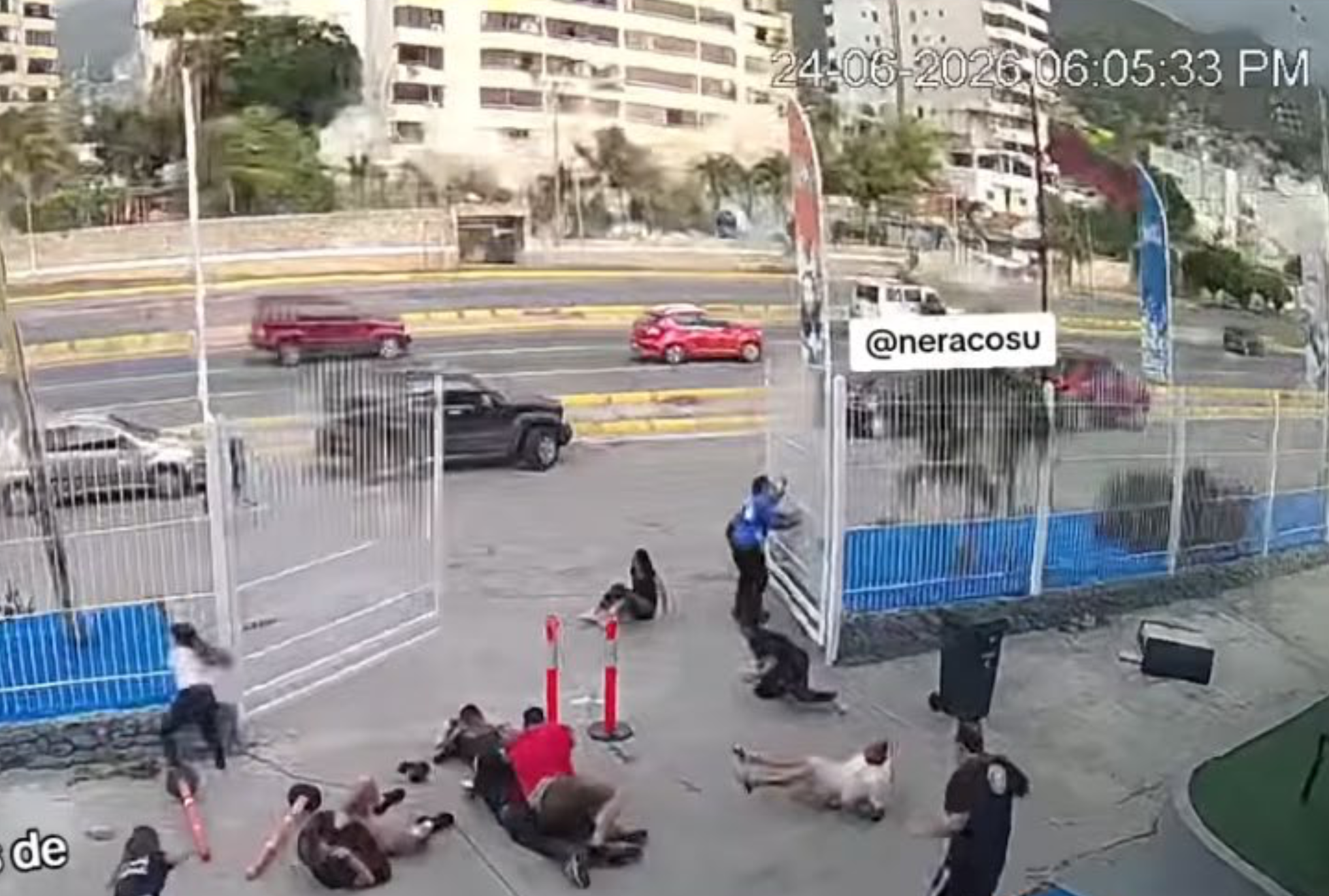
The photographs below, taken just 2 sec apart (extracted from a youtube video distributed by Paul Somerville) shows how quickly the building in the background began to collapse at the open ground floor level, and people evacuating the camera-bearing building were thrown to the ground very soon after the onset of the strong S-wave pulse.
https://www.youtube.com/watch?v=jCZgv7fLJmY
References
Espinosa A. F., and Algermissen S.T., 1972. Ground Amplification Studies in the Caracas Valley and the Northern Coastal area of Venezuela.
Seed, H. B. and Alonso, G. (1974), “Effects of Soil Structure Interaction in the Caracas Earthquake of 1967”, Proceedings, First Venezuelan Conference on Seismology and Earthquake Engineering, October.
Urbina, L., and Grases, J., 1983, Research in seismology and earthquake engineering in Venezuela: Earthquake Information Bulletin (USGS), v. 15, no. 1, p. 32-38.
Venezuelan Official Seismic Commission 1969. The Caracas earthquake of July 29, 1967. Proc. 4th WCEE Santiago Chile.